Flood Inundation Map
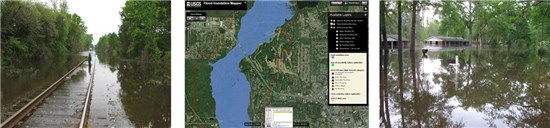
Through a partnership between the City of Valdosta, Lowndes County and the U.S. Geological Survey (USGS), a Flood Inundation Map of the Withlacoochee River near Valdosta, Georgia has been completed. The $135,000 project began in late 2016 and was completed in early 2018.
The USGS Flood Inundation Mapping (FIM) Program focuses its efforts at state and local levels to help communities understand flood risk and make cost-effective mitigation decisions. In the last 20 years, a number of large flood events have occurred in Georgia showing the need for these FIM projects. The South Atlantic Water Science Center has worked with local cities and counties in Georgia to produce seven (7) FIM sites, which include:
- Flint River in Albany
- Peachtree Creek in Atlanta
- Sweetwater Creek in Cobb and Douglas Counties
- Suwanee Creek in Gwinnett County
- Big Creek in Alpharetta and Roswell
- South Fork Peachtree Creek in DeKalb County
- Withlacoochee River in Valdosta
To learn more Flood Inundation Maps, here are some helpful links:
- USGS Flood Inundation Mapping (FIM) Program
- USGS Flood Inundation Mapping Program Flyer
- Scientific Investigations Report 2018-5011 - Flood Inundation Maps for the Withlacoochee River from Skipper Bridge Road to St. Augustine Road, within the City of Valdosta, Georgia and Lowndes County, Georgia
- Flood Inundation Maps
- USGS Flood Mapper Presentation